Seven Days in Whistler, the Sea to Sky Corridor and Vancouver
The Route in Brief
This is the full version of the Sea to Sky corridor: enough days to see Vancouver properly, drive the highway slowly through Squamish, settle into Whistler Village rather than rush through it, and still have two full hiking days in the mountains behind the resort. It needs a car, a week off, and — this matters more than almost anything else on the trip — a BC Parks day-use pass booked in advance for both Garibaldi Lake and Joffre Lakes.
| Day | Base | Focus |
|---|---|---|
| 1 | Vancouver | Arrival, city, YVR logistics |
| 2 | Squamish | Sea to Sky Gondola, Stawamus Chief, Shannon Falls |
| 3 | Whistler | Village Stroll, settle in |
| 4 | Whistler | Whistler Blackcomb, Peak 2 Peak Gondola |
| 5 | Whistler | Garibaldi Lake hike |
| 6 | Pemberton | Joffre Lakes hike |
| 7 | Vancouver | Return drive |
Day 1: Arrive in Vancouver
Fly into Vancouver’s airport and spend the day and night in the city rather than rushing straight up the highway — Highway 99 is far better driven fresh than jet-lagged. Pick up the rental car either at the airport or the next morning; parking is easy to arrange for one night in most downtown hotels. Use the afternoon to walk the seawall or Granville Island, and check the BC Parks website for both Garibaldi Lake and Joffre Lakes while you still have reliable wifi, since day-use passes for high season sell out and need booking before you leave the city.
Day 2: Vancouver to Squamish, Sea to Sky Gondola
Leave Vancouver by mid-morning for the roughly one-hour drive to Squamish, the first real stop on the Sea to Sky Highway. The town sits beneath the Stawamus Chief, one of the largest granite monoliths in the world, and the Sea to Sky Gondola climbs from the highway to a viewing deck and suspension bridge in about ten minutes, no hiking required. If you’d rather earn the view, the Chief’s summit trail uses chains and ladders and takes most of a day — a guided option removes the guesswork on route-finding and timing:
a guided hike up the Stawamus Chief with a local outfitterAdd Shannon Falls next door, a five-minute walk from the parking lot to a 335 m drop, before continuing the final 45 minutes to Whistler. First-timers who would rather have someone else handle the driving and commentary along the way can book the corridor as a guided run instead:
a day tour from Vancouver covering the Sea to Sky Gondola on the way to WhistlerDay 3: Settle Into Whistler Village
Whistler Village is pedestrian — cars stay at its edge, and the Village Stroll is walked end to end in about fifteen minutes. Spend the morning finding your bearings: check into accommodation, walk the Stroll past the base of Whistler and Blackcomb mountains, and browse the shops and patios without an agenda.
In the afternoon, visit the Squamish Lil’wat Cultural Centre in the Upper Village, run by the two Nations on whose shared territory Whistler stands, or the Audain Art Museum for its Northwest Coast and Emily Carr collections. This is also the day to confirm tomorrow’s mountain plans and, if hiking Garibaldi Lake two days from now, to double-check gear: sturdy boots, layers, and an early alarm.
Day 4: Whistler Blackcomb and the Peak 2 Peak Gondola
Ride up Whistler Blackcomb, the largest ski area in North America by skiable terrain, and take the Peak 2 Peak Gondola between the two mountains — about 4.4 km end to end, an unsupported span of roughly 3 km, up to 436 m above the valley floor, and an 11-minute ride each way. In summer this is alpine sightseeing rather than skiing: short trails, viewpoints and, weather permitting, sweeping views back down to the village and Alta Lake. For a different angle on the same peaks, and one that needs no walking at all:
a helicopter tour over Whistler and BlackcombCome down by mid-afternoon and rest — the next two days are the physical core of the trip.
Day 5: Garibaldi Lake
This is a full hiking day, not a stroll. Garibaldi Lake, inside Garibaldi Provincial Park, is reached by a well-graded trail of roughly 18 km round trip with about 800 m of elevation gain — turquoise, glacier-fed water backed by the Black Tusk, and one of the reasons this corridor draws hikers as much as skiers.
Start early, both to beat the crowds and to leave enough daylight margin: most parties take six to eight hours round trip. You must already hold a BC Parks day-use pass for this specific date, booked online — arriving without one, or finding the day’s allocation sold out, is the single most avoidable disappointment on this route. Prefer a guided day out rather than navigating trail logistics alone:
a guided Garibaldi Lake hiking day tripDay 6: North to Pemberton for Joffre Lakes
Drive north from Whistler through Pemberton, about 30 minutes past the village, to Joffre Lakes. The loop here is shorter than Garibaldi but no less rewarding: roughly 10 km round trip with about 400 m of ascent, passing three glacier-fed lakes that get more intensely turquoise as you climb — Lower, Middle and Upper Joffre. This is one of the busiest trails in British Columbia, so an early start matters as much for parking as for the light.
Before you drive up, verify two things directly on the official BC Parks page rather than assuming: that you hold a valid day-use pass for the date, and that the park is actually open. Joffre Lakes has been closed for several periods since 2023 under an agreement with the Lil’wat and N’Quatqua Nations, and a closure announced with little notice at the end of a long drive is the costliest mistake this itinerary can produce. Build in a backup — a quieter walk around Lost Lake or the Train Wreck Trail back in Whistler — in case the park is closed on your date.
Day 7: Return to Vancouver
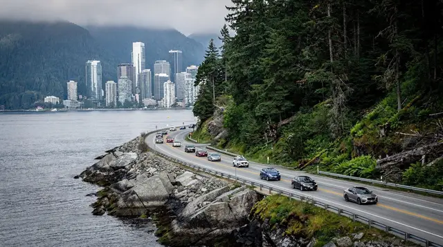
The drive back is about 121 km and takes roughly 1 h 45 with no stops, closer to 2 h 30 with a coffee break or a last look at Howe Sound and the Britannia Mine Museum at Britannia Beach. Leave enough buffer before a flight — Highway 99 is a single road with no realistic detour, and rockfall, snow or an accident can close it for hours with no warning, even outside winter. Time the return for the morning if your flight is in the afternoon or evening, and treat the drive itself as the last stop on the trip rather than an afterthought.
Trailhead Parking and Wildlife Notes
A booked day-use pass gets you past the barrier at Joffre Lakes and Garibaldi Lake; it does not guarantee a parking space. Both lots are small relative to demand in July and August, and the Joffre Lakes lot in particular is often full well before mid-morning on weekends, forcing latecomers to park along the highway shoulder and add 20-30 minutes of walking each way. Arriving as close to your pass window’s opening time as possible, rather than mid-morning, is the single best way to avoid this. Fuel up in Whistler or Pemberton before either hiking day — there is no fuel station on the access roads to either trailhead, and cell signal drops out completely once you leave the highway.
Both trails run through black bear habitat, not grizzly, but the safety basics still apply: bears are most active around dawn and dusk, food and scented items belong in the car boot rather than the cabin or a day pack left at the trailhead, and hiking in a group while talking normally is enough to avoid most surprise encounters. Trail signage at both parks posts recent sightings — read it before setting off.
Budgeting the Week
Quoted prices in Canada are before tax. Accommodation carries 5% GST plus 8% PST and a further 3% Municipal and Regional District Tax, so a room rate can run close to 16% higher at checkout than the number advertised. Restaurant bills expect a 15-20% tip on top, and this is not usually included on the printed cheque.
A rental car booked for the full week is normally cheaper than renting separately in Vancouver and Whistler, and dropping it back at the same location you collected it from avoids a one-way fee. If any part of this trip falls between 1 October and 30 April, winter tyres or chains are a legal requirement on Highway 99, not a suggestion, and rental desks in Vancouver do not always fit them by default outside the ski season proper — ask specifically when booking.
FAQ: Planning This Whistler and Sea to Sky Week
Do I need a car for this itinerary?
Yes. This route covers Vancouver, Squamish, Whistler and Pemberton along Highway 99, and Joffre Lakes and Garibaldi Lake trailheads are not served by public transport. A rental car picked up in Vancouver is the practical option.
Do I need a permit for Garibaldi Lake and Joffre Lakes?
Both are inside BC Parks, and in high season each requires a free day-use pass booked online in advance. Book Garibaldi Lake and Joffre Lakes separately, on the days you plan to hike, before you leave Vancouver.
Is Joffre Lakes currently open?
Joffre Lakes Provincial Park has been closed for several periods since 2023 under an agreement with the Lil’wat and N’Quatqua Nations. Always check the official BC Parks status page in the days before your visit, not weeks ahead.
How hard is the Garibaldi Lake hike?
It is a full day, not a stroll: about 18 km round trip with roughly 800 m of elevation gain on a well-maintained but steadily climbing trail. Fit hikers with good boots and an early start manage it comfortably in one day.
Can Joffre Lakes be done as a day trip from Whistler instead of Pemberton?
Yes. Joffre Lakes sits about 40 minutes north of Whistler on Highway 99, so this day works equally well based in Whistler Village if you would rather not change accommodation for one night.
What is the best time of year for this itinerary?
Late June through September, once high-alpine snow has cleared from Garibaldi Lake and Joffre Lakes. July and August give the most reliable trail conditions and the warmest turquoise-lake color.
How long is the drive back from Whistler to Vancouver?
About 121 km on Highway 99, roughly 1 h 45 with no stops and closer to 2 h 30 with the scenic pull-offs most visitors use on the way down.
tours.7 days
Verified deep-linked GetYourGuide tours. Book through these links and we earn a small commission at no cost to you.
GetYourGuide does not provide a product photo for this activity — the image shows the meeting point, photographed by us.